


I’ve moved this website to JimClifford.ca.
Filed under: Uncategorized | Leave a comment »
I’ve moved this website to JimClifford.ca.
Filed under: Uncategorized | Leave a comment »
 From ActiveHistory.ca:
The Lower Lea Valley, currently undergoing a massive redevelopment project in preparation for the next Summer Olympics, underwent a number of equally remarkable transformations as London’s heavy industry migrated to the city’s eastern periphery in the second half of the nineteenth century. In this talk, Jim Clifford explored some of the findings of his PhD dissertation on the environmental problems created by half a century of urban-industrial development, and the challenges this history poses for redevelopment.
His lecture, “From a Pastoral Wetland to an Industrial Wasteland, and Back Again? An Environmental History of the Lower Lea River Valley, the Site of the 2012 London Olympics,” is part of the pan-Canadian NiCHE Speakers’ Series and the Mississauga Library System’s ‘History Minds’ series.
Click here to listen to the talk.
Filed under: Uncategorized | Leave a comment »
Reposed from ActiveHistory.ca:
A reminder to our readers that you are all invited to the second lecture in the Mississauga Library System’s ‘History Minds’ series, co-hosted with ActiveHistory.ca. The second talk will be on Thursday, April 14th at 7:30PM in Classroom 3 at the Mississauga Central Library (see below the cut for directions).
“From a Pastoral Wetland to an Industrial Wasteland, and Back Again? An Environmental History of the Lower Lea River Valley, the Site of the 2012 London Olympics.” [part of the pan-Canadian NiCHE Speakers’ Series]
With Dr. Jim Clifford.
The Lower Lea Valley, currently undergoing a massive redevelopment project in perpetration for the next Summer Olympics, underwent a number of equally remarkable transformations as London’s heavy industry migrated to the city’s eastern periphery in the second half of the nineteenth century. In this talk, Jim Clifford will explore some of the findings of his recently defended PhD dissertation on the environmental problems created by half a century of urban-industrial development and discuss some of the challenges this posed for redevelopment. Continue reading
Filed under: Public Talk | Leave a comment »
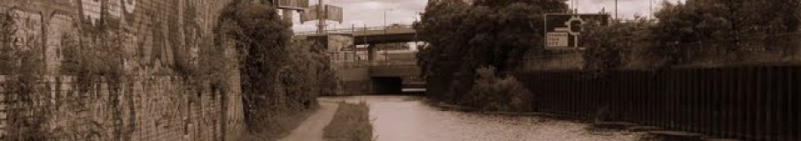
 The clock is counting down to the start of the 2012 Olympics in London. The main Olympic Park [map] is located in East London in heart of the Lower Lea Valley, which happens to be the same place I studied in my recently completed PhD. My research demonstrated the close correlation between the degraded environmental conditions and the disadvantaged social conditions in the sections of West Ham built on the wetlands. I ended my dissertation wondering whether the current multi-billion dollar project to clean up the environment for the Olympics might result in a comparable effort to clean out the socially undesirable people from this landscape.
An article in the Guardian, “Houseboaters being ‘socially cleansed’ from Olympics area,” suggests this process might be underway. House boaters are concerned that British Waterways are going to increase the mooring costs along canals in the Lower Lea:
British Waterways, which manages 2,200 miles of canals and rivers, has put forward changes to the mooring rules on the river Lea, in east London, that could increase the cost of living on the waterway from about £600 to £7,000 a year. Residents see the move as a deliberate attempt to drive them away. A draft note from British Waterways on 6 December 2010, seen by the Guardian, says: “The urgency … relates to the objective of reducing unauthorized mooring on the Lea navigation and adjacent waterways in time for the Olympics.” Continue reading
Filed under: West Ham and the Lea in the News | Tagged: 2012 Olympic Park, Environmental History, houseboaters, River Lea, social history | Leave a comment »
On January 20th I successfully defended my dissertation, “A Wetland Suburb on the Edge of London: a Social and Environmental History of West Ham and the River Lea, 1855-1914.” Now I’ve just got the small job of converting it into a book ahead. I’ve included the abstract for this project below. If anyone has suggestions on where I should try to publish an urban environmental history of London/West Ham, I’d be happy to hear them.
Abstract:
This dissertation examines the multifaceted connections between ecological change on the wetlands where the River Lea meets the Thames Estuary and the development of a young suburb on the edge of London. West Ham was a patchwork of heavy industry, rivers, slums, farmlands and low-lying marshes. The difficult environmental conditions of this wetland suburb provided compelling material for a study of the links between the environment and urban society and politics. West Ham was not a typical suburb: growth of industry and working-class housing outpaced growth of commuter residential communities. Nor was it much like London’s older industrial core, as pockets of the wetlands and farms remained undeveloped, distorting boundaries between the city and the receding countryside. As industry transformed the wetlands, socially marginalized people in West Ham suffered alongside the natural environment from pollution and flooding.
This dissertation, by placing environmental change, and the interconnections between social and ecological degradation at its centre, demonstrates the importance of the environment in shaping urban, social, and political history. Droughts, disease, and floods highlighted the dysfunctional environmental conditions in this wetland suburb. The deteriorating condition of the Lower Lea contributed to economic problems and to the end of industrial growth. These conditions caused both the public and the electorate in West Ham to increasingly demand action from the borough council to ensure the water supply, improve housing conditions and health, and to protect the low-lying districts from floods. Crisis after crisis caused by the suburb’s location on the wetland edge of Greater London demonstrated that the population of West Ham could not rely on private interests to protect the public good. These particular environmental conditions, along with the connected social distress, contributed to the rise of Labour and socialist politics in the suburb and to a more general transition from liberalism to social democracy in West Ham. The public demanded stable environmental and economic conditions, and they increasingly turned to government and its experts, instead of private enterprise and market forces, to solve the many problems facing this industrial wetland suburb.
Table of Contents
Filed under: Uncategorized | Leave a comment »
A recent addition to the Google Earth software incorporated aerial photographs of London from 1945. If you have Google Earth installed on your computer you can explore these maps yourself. Navigate to London and then click on the Clock button to find a slider that shows the historical photos.

Below are a number of sample photos from West Ham.

West Ham 1945
Filed under: Maps | Tagged: London 1945 | Leave a comment »
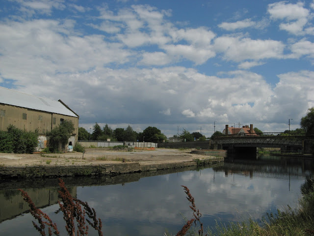
Here is an important news story about the future of the Lower Lea Valley:
” THE final jigsaw piece in post war city planners’ ambitions to link London’s green belt with the Thames will be realised in time for the 2012 Olympics, nearly 70 years after its initial inception.
The London Thames Gateway Development Corporation has given the green light to build the backbone for a new urban park in east London, linking the Olympic Park at Stratford with the Thames at the East India Dock Basin.”
Read the whole story at the East London Advertiser
Having walked around both sides of the mouth of the Lea and along the whole length of the Lea from the Limehouse Cut to Waltham Abbey, I’m pretty happy to see planning approval for the final link of pathways along this stretch of Bow Creek. I hope they find a way to maintain and highlight some of the industrial heritage alongside river. I’m a big fan of the wetlands created out of the East India Dock basin and I hope this kind of hybrid of renationalisation and industrial heritage can work in other spaces along this new corridor of parkland.
Filed under: West Ham and the Lea in the News | Tagged: Environment, Lower Lea, Park, West Ham | Leave a comment »

Birds eye view of Thames Ironworks (Newham Story)
Two years ago I published a photo essay entitled “The Urban Periphery and the Rural Fringe : West Ham’s Hybrid Landscape” in a special environmental history issue of Left History (Spring/Summer 2008). The issue is now online and I’ve uploaded the PDF of my essay here. To see a lot more historical photos of West Ham take a look at the Newham Story website.
Filed under: Publications | Tagged: Historical Photos, Left History, River Lea, West Ham | Leave a comment »
Here is an Exploring Environmental History podcast on my research:
Podcast 31: Environmental History of the 2012 Olympic site: the Lower River Lea
Here is Jan Oosthoek’s introduction to his interview with me:
Former industrial sites worldwide are constantly reinvented and redeveloped reflecting changes in economies and societies over time. Nowhere else in Europe is regeneration of a former industrial site more spectacular than the 2012 Olympic site on the banks of the River Lea in West Ham, East London. The creation of the Olympic park promises the rehabilitation of the Lower Lea Valley by restoring its eco-system and revitalising the community of the area.
But the Lower River Lea has a long history, going as far back as the 11th century, of industrial development and associated environmental degeneration. Jim Clifford, a doctoral student at York University in Toronto, talks in this episode of the podcast about the environmental and social history of West Ham and the Lower Lea River. He highlights that there have been attempts in the earlier 20th century to improve the Lea River’s environmental and social conditions but that the high expectations of these schemes were not always met.
Find other podcasts in this series by Jan Oosthoek here.
Filed under: West Ham and the Lea in the News | Tagged: 2012 Olympics, Exploring Enviornmental History Podcast, River Lea History, West Ham History | Leave a comment »

The recent past

The future
Promotional literature for the 2012 Olympic games promises to transform the environmental and social conditions in the Lower Lea Valley: “The natural river system of the valley will be restored, canals would be dredged and waterways widened… The rehabilitation of the Lower Lea Valley lies at the heart of the Olympic legacy to east London, restoring an eco-system and revitalising an entire community.”[1] This, however, is not the first time the Bow Back Rivers have been the focus of a major public works project with the goals of improving social and environmental conditions in West Ham. Half a century of rapid industrial and suburban growth left the tidal Back Rivers of the Lower Lea in rough condition by the end of the nineteenth century. The polluted and silted streams decreased the rivers utility for transportation, threatened public health, and increased the threat of flooding. Continue reading
Filed under: Research Abstracts | Tagged: 2012 Olympic Park, Bow Back Rivers, London Canals, Lower Lea, Lower Lea History, West Ham History | 1 Comment »

